Grenoble -around
the Railway.
2. The layout of the railway around the town.
-disused,
forgotten, taken away or abandoned lines.
2. The layout of the railway around the town.
All
the pictures can be enlarged with a mouse click!
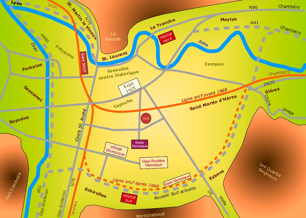
Here is a map showing the location of the PLM/SNCF
railway lines before and after the 1968 Winter Olympics. Motorways, in
part carried out for the games, are shown in grey dashes.
The Olympic facilities were established on the old airfield and a new hospital built nearby at Echirolles.
The Grenoble cultural centre, now called MC2, was built near the old railway line.
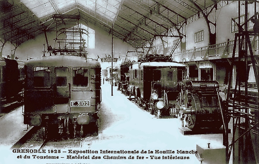
The relocation of the railway line towards Echirolles, next to the south ring road, freed up space for the creation of new neighbourhoods and a wide bicycle track from the station to the University Campus. This space is now being used to create a green corridor. The International exhibition of water power and tourism was held in Grenoble between May and October 1925. This event enabled the demolition of part of the military fortifications and the creation of Paul Mistral park, named after the mayor of Grenoble at that time.
From a railway point of view, there was a building devoted to the main railway lines and another concerning railway material.
The only remaining vestige is the 95 meter high Perret tower. This was the first tower in reinforced concrete, but it's present state is such that it's future seems uncertain.
A new City Hall was also built for the Grenoble Olympic Games on the location of the 1925 exhibition ground, now the park Paul Mistral.
The Verderet, a mountain stream that comes from Eybens, crosses this park but now is closed in a big buried drain 6kms long which empties itself into the Isère river near the 'Île Verte'.
The Olympic facilities were established on the old airfield and a new hospital built nearby at Echirolles.
The Grenoble cultural centre, now called MC2, was built near the old railway line.
The relocation of the railway line towards Echirolles, next to the south ring road, freed up space for the creation of new neighbourhoods and a wide bicycle track from the station to the University Campus. This space is now being used to create a green corridor. The International exhibition of water power and tourism was held in Grenoble between May and October 1925. This event enabled the demolition of part of the military fortifications and the creation of Paul Mistral park, named after the mayor of Grenoble at that time.
From a railway point of view, there was a building devoted to the main railway lines and another concerning railway material.
The only remaining vestige is the 95 meter high Perret tower. This was the first tower in reinforced concrete, but it's present state is such that it's future seems uncertain.
A new City Hall was also built for the Grenoble Olympic Games on the location of the 1925 exhibition ground, now the park Paul Mistral.
The Verderet, a mountain stream that comes from Eybens, crosses this park but now is closed in a big buried drain 6kms long which empties itself into the Isère river near the 'Île Verte'.


Some Internet Links:
- http://www.hannibal-dans-les-alpes.com/
- http://1900anosjours.hpsam.info/photos/grenoble/exposition-internationale-1925.php
- http://insitu.revues.org/217#tocto1n2
- http://www.rocadesud.com/realisations/?actmenu=estacade&ID_rubrique=4
- http://www.artmajeur.com/?go=artworks/display_mini_gallery&image_id=2564745&login=nesse
- http://www.arcachon-nostalgie.com/roger_expert.htm
- http://insitu.revues.org/217#tocto1n2
- http://histoire.trains-en-vadrouille.com
- http://www.euro-photos-trains.com/sncf67300BBC.htm
- http://cccp.trainprovence.free.fr/cccp/article-alpazur2007.html
- http://clode.chez-alice.fr/fretgrenoble.htm
- http://www.lineoz.net/forum/viewtopic.php?f=3&t=3657&start=0
- http://membres.multimania.fr/stephanerevel/histo.htm
- http://www.ville-st-martin-dheres.fr/industrialistation.html
- http://emmatortue.wordpress.com/2009/05/15/ces-biscuits-ont-fait-les-delices-de-mon-enfance/
- La Vie du Rail, N°'s 1104, 1129, 1131 et 1137, Éditions NM Paris, 1967 et 1968.
- Le Bassin du Drac, Auguste Bouchayer. Revue de géographie alpine. Tome 13 N°3. pp. 549-621. 1925.
- Histoire Populaire de Grenoble, Alphonse Vernet. Gratier, 1896.
- Le Chemin de Fer de Grenoble à Villard de Lans. Philippe Guirimand et Patrice Bouillon, 2000.
- Grenoble Autrefois, Jean-Jacques de Corcelles. Horvath, 1996.
- Une Industrie dans la Ville, Bouchayer & Viallet à Grenoble. Hervé Bienfait. Libris, 2004.
- L'Illustration Economique et Financière, numéro spécial, Grenoble et l'Isère, 1923.
- Les Voies Ferrées du Dauphiné, Henri Boyer et Patrice Bouillon, 1983.
- Guide Catalogue Officiel de l'Exposition Internationale de la Houille Blanche et du Tourisme, Saumane 1925.
- Grenoble Autrefois, Claude Muller, Editions des Quatre Seigneurs, 1974.
- Du Tram au Tag, JM Guétat, W Lachenal, G Muller, La Vie du Rail,1987.
